


When you think about the Incas, does come to mind? While that might be where your destination starts or ends in Peru, there is so much more to see in the Sacred Valley of the Incas, or El Valle Sagrado de los Incas. Look up along the Urubamba River and Valley to see Andes Mountain peaks stretching to a height of 20,000 feet. It is over these steep hillsides that the Incas managed to move massive stones without the help of the wheel. They had no iron tools to cut the stones, but still the pieces fit together so tightly that not even a knife blade can slide between them. The “how’s” are part of the secrets to which we might never know the answers. Huge circular terraces at Moray were thought to be where Incas conducted experimental agriculture. Carved into the mountains are also thousands of small salt ponds, Salineras de Maras, or Inca salt pans. All of this is located in the Peruvian Andes, with Cusco on one end and Machu Picchu on the other; this is the heartland of the Inca Empire. This is the Sacred Valley of the Incas.

Inca salt ponds, Sacred Valley in Peru. The photographer wrote, “Indians mined salt slopes of the valley from pre-Inca times. Today, 700 to 800 families owning some 3600 basins are organized as a cooperative. The total annual production varies between 160 and 200 tons.” Photo #1 by David (Wanaku)

If you zoom out, this is Sacred Valley of the Incas in the Peruvian Andes. The photographer noted that Sacred Valley has “numerous archaeological monuments and indigenous peoples. This valley was appreciated by the Incas due to its special geographical and climatic qualities.” Photo #2 by Alfredo Miguel Romero

Sacred Valley patchwork fields. Colonial documents referred to this valley as the ‘”alley of Yucay.” Photo #3 by McKay Savage from London, UK
 Cusco, Peru")
Inca terraces of Moray. According to En Peru, “Some say Moray was an Inca laboratory used to test how different crops would perform at different temperatures. Others say it was a more of a nursery where crops were bred and cross-bred, varieties created and new foreign crops tested. A third group says it was just an ingenious means to grow warmer climate maíz or corn in the local cold climate. Whoever is right, this archaeological site of concentric circles of terraced farms, forming craters in the landscape, are a fascinating sight to behold.” Photo #4 by Boris G

Imagine coming through the mountainside to see the shocking patch of white and thousands of salt ponds. Salinas de Maras is clearly visible on an aerial map view. Photo #5 by dachalan

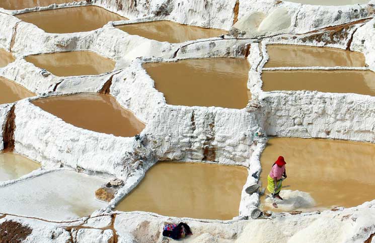
Salt pans at Maras during wet season. “We visited during the wet season when yield is not optimal; the ponds are also more colorful during dryer times.” The photographer added that families working the ponds make less than $3 per 50 kg bag of top quality salt. Photo #6 by Pierre Pouliquin

Inca Salt Ponds, “Salineras.” Salt has been harvested from the briny waters of the Salineras spring for thousands of years. There are thousands of salt pans nestled in a canyon, which are used to evaporate water to extract the salt. The salty water is directed to the ponds by an intricate network of channels. Once the pond is filled, the flow of water is cut and it is allowed to dry. Salt precipitates in crystals, and when dry it can be harvested. The salt pan is run on a cooperative system.” Photo #7 by Pierre Pouliquin

Salt Pans during August. En Peru explains, “A saline stream once flowed through here before, in ancient times; it was captured and used for salt production. The stream was redirected to flow along channels higher up the walls of the gully and at each stage some water is let out to flow into man-made ponds that fill the rest of the gully. Once full, the water in the pond (or pan) is allowed to naturally evaporate leaving salt crystals that can be collected. The process is then repeated.” Photo #8 by dachalan

Salt pans, Salineras de Maras, are owned by locals. It’s back-breaking work, but some of the salt ponds “have been in the same family, passed down from generation to generation for as long as anyone can remember. They are formed into a cooperative and sell the salt together.” In fact, local residents and pond workers agree “that the cooperative system was established during the time of the Incas, if not earlier.” Photo #9 by dachalan

An ancient civilization thrived in this part of Peru. “It was called the Sacred Valley because it contains some of the best land in the region and was not a part of the Empire but the property of the Emperor or Inca himself.” Photo #10 by dachalan

Salt Mines are near Maras, which “was occupied when Cusco citizens left the Inca palaces in Cusco and had to migrate to other small towns as Maras and San Sebastian. This populated area was a necessary step for carriers and their mule trains that carried tropical products, specially coca leaves from thejungle to satisfy the needs of Cusco and the country.” Photo #11 by McKay Savage

Many people believe the salt pans were being used by pre-Inca natives, before Incas set up house in Sacred Valley, between 200 AD and 900 AD during the Chanapata culture. Photo #12 by McKay Savage

“Square-shaped salt ponds cascading like a chessboard down this part of the salt flats.” The photographer added, “The Salineras salt pans are among the most amazing sights in the Cusco area. Thousands of tiny terraces of white, pink and coffee brown evaporate salty mineral water to produce fine salt.”Photo #13 by McKay Savage

The photographer wrote, “It all starts with a hot spring highly loaded in salt; the water is directed to ponds downhill where salt is harvested after evaporation.” Wikipedia added, “As water evaporates from the sun-warmed ponds, the water becomes supersaturated and salt precipitates as various size crystals onto the inner surfaces of a pond’s earthen walls and on the pond’s earthen floor.” Photo #14 by Pierre Pouliquin

Salt ponds in Dec. Other people believe these salt ponds have been panned for centuries, but the water-flow system was developed by the Incas. Photo #15 by Emmanuel Dyan
 in Maras Peru in March")
It’s not like this is a major tourist attraction, but it is a strangely unique site to behold. Wikitravel said, “On the main route to Incan sites of Salineras and Moray, Maras is an otherwise unremarkable dusty town.” Photo #16 by Kenneth Moore

Some people make the trek through the Sacred Valley and to Machu Picchu via the Inca Trail along which these Pisac ruins can be found. The photographer wrote, “The terraces, called andenes, surrounding the Pisac ruins sits high over the Sacred Valley.” The residential zone of the Incan ruins at Pisaq is on top, but the ruins are also spread out on the mountains into a large agricultural section with terraces. Photo #17 by McKay Savage

Gorgeous Sacred Valley of the Incas patchwork fields and mountain landscape next to Moray. Photo #18 by Boris G

Moray is an archaeological site next to Cusco, Peru. It consists of several circular terraces created by the Incas as you can see in an aerial map view.Photo #19 by Boris G

Urubamba Valley. BBC said, “Peru’s Sacred Valley of the Incas stretches between Cusco, once the capital of the Inca Empire, and the legendary 15th-century city of Machu Picchu. Encompassing what was the fertile homeland of the Inca Empire (1438 to 1533), today the transcendent region – also known as the Urubamba Valley – is a quiet expanse of country that is steeped in Andean history and culture.” Photo #20 by Charles Gadbois

Sacred Valley, Ollantaytambo, mountain Inca archaeological site. You can view the Inca site on the mountainside in an aerial map. Ollantaytambo “is where the Incas retreated after the Spanish took Cuzco. Much of the town is laid out in the same way as it was in Inca times. The ruins of Ollantaytambo are largely of religious significance; they doubled as the the last and largest defensive structures near the plains below where the Incas defeated the Spaniards in battle.” Photo #21 by Emmanuel Dyan

“Ruins of granaries on the hillside over Ollantaytambo, an Inca archaeological site in the Sacred Valley.” The photographer wrote, “Reportedly grain was tipped in the uphill window, then removed from the downhill side.” Ollantaytambo “was once a country retreat for Inca royalty and nobility.” It was also where the Incas fought some of their last battles, resisting Spanish conquest from the still-intact fortress and staggered terraces rising up around the town. Climbing to the top of the village’s ceremonial center where Incas would worship, yields panoramic views of the Sacred Valley and across the Patakancha and Urubamba Rivers.” Photo #22 by Stevage

Regarding Pisac, the BBC said, “Trails lead over and through the terraces, tunnels, temples, tombs and ceremonial centre – all engineered by the Incas for farming, worshipping and bathing. The Sun Gate, included in many of the Inca’s lofted towns, perfectly frames the setting sun during biannual solstices, as it has and will continue to do for centuries. The splendid views down and across the Urubamba Valley rival those of Machu Picchu, and unlike the iconic site, visitors often have hushed Pisac almost entirely to themselves.” Photo #23 by Unukorno

Saksaywaman (Saqsaywaman) was an Inca military fortress above Cusco. The precision of the stone work shows us that the Incas were masters who supposedly had no “math” and no tools but rocks to chisel the boulders into fitting tightly together. It’s also said they didn’t write things down yet managed to keep excellent records. Saksaywaman is still used during Inti Raymi, a solstice festival that was a religious “Festival of the Sun” for the Incans.Inti Raymi “really was the celebration of the Winter Solstice – the shortest day of the year in terms of the time between sunrise and sunset. In Peru, which falls below the equator, the months of June and July are Winter months.” Photo #24 by McKay Savage from London, UK

Sacred Valley of the Incas has numerous ancient villages, temples and ruins besides the famous rediscovered “lost” city of Machu Picchu located farther north and higher up into the mountains. Photo #25 by Daniel Antunes

Tipón water channeling. The photographer noted, “What makes Tipón an interesting Incan site is the sophisticated water distribution through the agriculture terraces, water running through stone-lined channels and out spouts to different levels and parts.” Photo #26 by McKay Savage

Varied color and texture of stone mastery without motor, Incan walls at Pisac, Peru. Photo #27 by McKay Savage

Huchuy Qusqu, or “Little Cuzco” lies at an elevation of 11,800 feet (3,600 m) above the 3000-meter high town of Lamay and the Sacred Valley. It is not accessible by road. Photo #28 by Stevage

The mystery at Moray, Inca agricultural experiment station. The photographer points out, “Surprisingly, for wiki in GB, the function of this site is only hypothetical; it is not for wiki in other languages, nor for the locals who keep Quechua tradition (Quecha, language of the people ‘administered’ by the Inca).” Indeed when looking up Moray in languages other than English, its purpose for experimentation is stated as a fact. “At first glance, the site looks like a main auditorium and two secondary, smaller nearby. They consist of several terraces arranged in concentric circles. In fact, it was a center of Inca agricultural research where experiments were performed.” Photo #29 by Pierre Pouliquin

Inca terraces of Moray: The site contains unusual Inca ruins, mostly consisting of several enormous terraced circular depressions, the largest of which is about 30 m (98 ft) deep. The purpose of these depressions is uncertain, but their depth and orientation with respect to wind and sun creates a temperature difference of as much as 15 °C (27 °F) between the top and bottom. This large temperature difference was possibly used by the Inca to study the effects of different climatic conditions on crops. In other words, Moray was perhaps an Inca agricultural experiment station. As with many other Inca sites, it also has a sophisticated irrigation system.” Photo #30 by Os Putos

If Inca stonework is what you want to see, many photographers suggested Pisac where viewing the ruins is not as crowded as other ruins. En Peruwrote, “They might not be in a location quite as beautiful as Machu Picchu, or on a scale quite as monumental as Sacsayhuamán, but the stonework here is some of the best you will ever see in Peru or elsewhere.” Photo #31 by Vautrin_Baires

View of Machu Picchu from Wayna Picchu (the high hill that rises behind machu in all photos). Photo #32 by Rodrigo Alvarez

Machu Picchu may be your “main” destination, but there are plenty of mysterious ruins and secrets in the Sacred Valley of the Incas. Photo #33 by Pedro Szekely

Moray Terraces: “There are three separate ‘bowl’ shaped groups of concentric terraces. One has been restored and is being used by local farmers. Each has stone retaining walls with carved channels for carrying water and steps for climbing into and out of the structure. There was possibly a ceremonial use for the site as well. But none is recorded by the Spanish writers of the conquest and there is no ceremonial folk tradition associated with the Terraces.”Photo #34 by McKay Savage

Urubamba River, natural beauty in the Sacred Valley. There are some massive pieces of rock left abandoned by the Incas along the Inca trail; they are much more massive than these and were pulled by humans and not oxen. The huge abandoned rocks are called “weary stones.” Photo #35 by Rod Waddington from Kergunyah, Australia

Llama designs built into the walls at Choquequirao; it is considered the smaller “sacred” sister of Machu Picchu. Photo #36 by Mark Rowland & #37 by Corentin Kopp

Amazing giant rocks, architecture so precise a knife can’t be wedged between the massive stones. Can you imagine the Incas moving those without the benefit of wheels? Photo #38 by Martin St-Amant

It might seem a bit odd, but today in the Sacred Valley of the Incas, visitors can go bungee jumping, horseback riding, hot-air ballooning, paragliding, mountain biking, trekking, white-water rafting and ziplining. Photo #39 by
McKay Savage

Meanwhile, as a polar opposite of tourists trying out extreme sports in the Urubamba Valley, locals try to etch out a back-breaking living by mining salt at Maras. Photo #40 by Emmanuel Dyan

October afternoon at the salt pond of Maras. Machu Picchu is less than a two hour drive north from here. As you have seen, the Sacred Valley in Cusco is full of salt, stones and secrets that leave questions to which we may never know the answers. Photo #41 by McKay Savage

Viva El Peru, Inti Raymi solstice festival, Sacred Valley of the Incas. Frommers stated, “The Incas built several of the empire’s greatest estates, temples, and royal palaces between the sacred centers of Cusco and Machu Picchu, positioned like great bookends at the south and north ends of the valley.”Photo #42 by McKay Savages


.jpg)