Cities change: skyscrapers go up, row houses are torn down, neighborhoods gentrify, earthquakes destroy. Vintage photographs of cities can be fascinating in and of themselves, but the familiar unfamiliarity of these time-warped photographs are especially intriguing.
From San Francisco to St. Petersburg, here are how cities have changed—and not changed—over the years. See history peek through familiar modern sights.
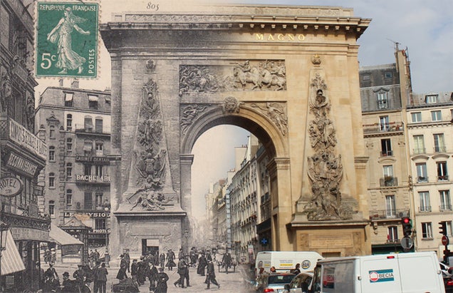
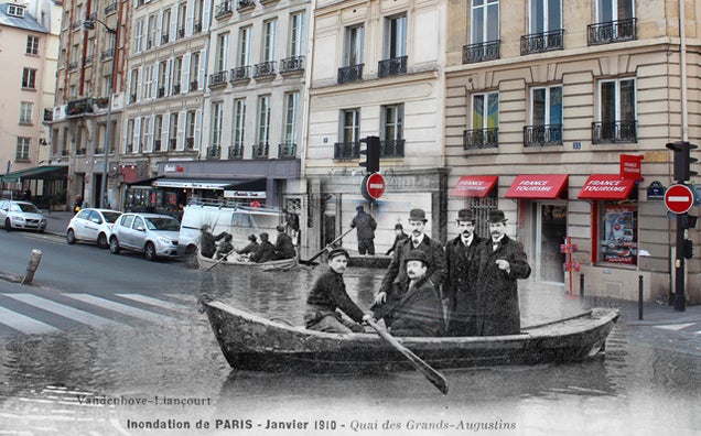
Postcards of Paris
Porte Saint Denis in the 10th arrondissementQuai des Grands-Augustins during the floods of 1910
The French blogger behind Golem13.fr went around snapping photos of Paris last month, and then stitched them together with postcards from the early 19th century. Check out more of the work, including Parisian icons like Notre Dame and Moulin, over at Golem13.fr.
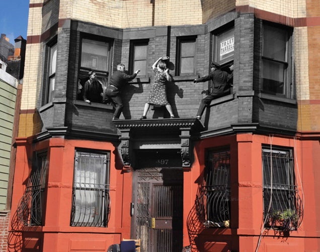
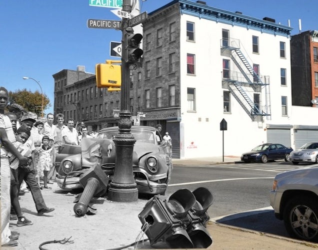
The Crimes of New York
Edna Egberg climbed into her ledge fighting with policemen, 1942.A stolen car smashed into the streetlight in Brooklyn, 1957.
Using the archives of the New York Daily News, photographer and historian of theNew York Press Photographers AssociationMarc Hermann put old crime scenes into their modern-day contexts. As Alissa Walker observed writing about these photographs for Gizmodo, it’s stunning how little New York City has changed over the decades. Other than a coat of new paint, the buildings are still largely intact and unchanged. [New York Daily News]
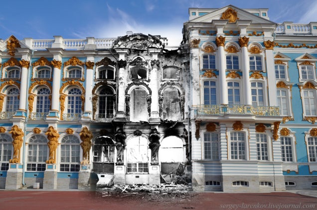
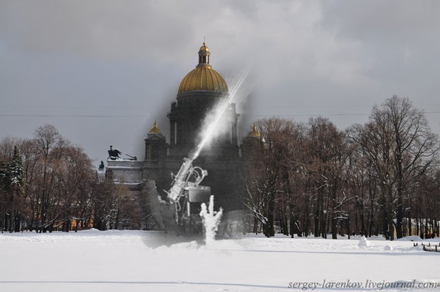
Siege of Leningrad (St. Petersburg)
The Catherine Palace, summer residence of the Tsars, after fire.Anti-aircraft machine-gun “Maxim” in Senate Square.
In his introduction to these photos of Leningrad (now St. Petersburg), Sergie Larenkov writes in his idiosyncratic English, “Dear friends, if you’re interested in travel into the past, I will try to help you. But be warned, the history often hides a very scary pages, and return to the present is much more pleasant than to travel into the past.” Over dozens of photos, a gilded, modern city is merged with streets full of soldiers, tanks, and dead bodies. [Sergie Larenkov]
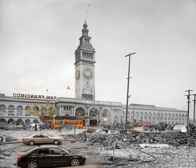
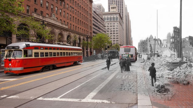
San Francisco after the 1906 Earthquake
Ferry BuildingMarket Street
Inspired by Sergie Larenkov’s St. Petersburg photos, photographer Shawn Clover began a project documenting an episode of destruction of his own city, San Francisco. The photos inFade to 1906, which he’s turning into a book, combine rubble-filled streets with the gleaming modern cars. Prints of these photographs are also available for purchase on his website. [Fade to 1906]
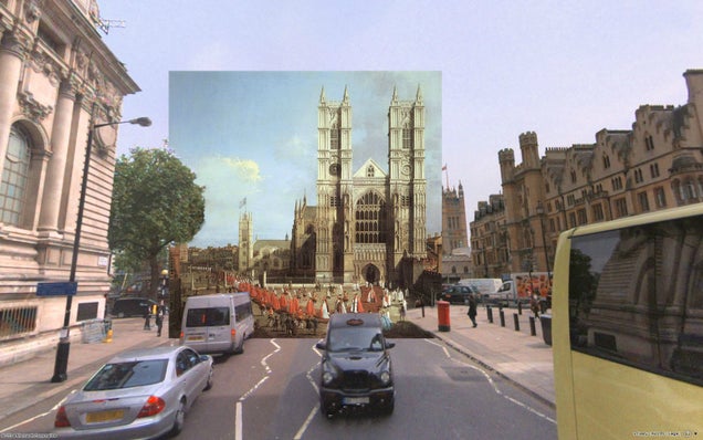
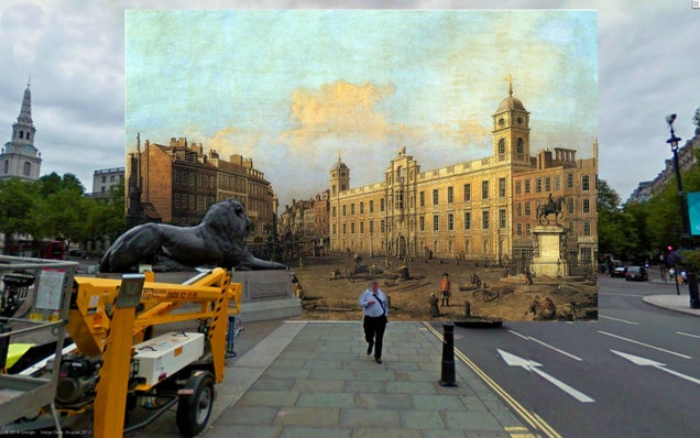
18th Century London in Paintings
Westminster Abbey with a Procession of Knights of the Bath (1749)Northumberland House (1752)
Italian painter Canaletto was a prolific chronicler of 18th-century London. Earlier this year,reddit user shystone took Canaletto’s centuries-old paintings and put them into Google Street View, juxtaposing two very different ways we vicariously view cities. Her photo mashups hit the familiar sites, and her captions are a lovely walk through London history. [Reddit]
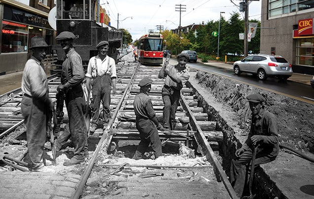
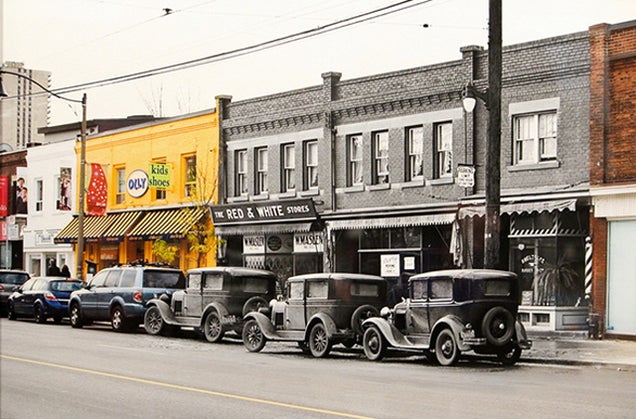
Toronto
Driving through the Toronto neighborhood where his mother grew up, Harry Enchin began thinking about his changing city. Thus began Toronto TIME, a photo project both chronicling and contrasting decades of the city’s history. Check out Enchin’s website for more of his work and news of any upcoming exhibitions.
The world is a big, beautiful place. Let’s keep it that way. Here are 10 places that will never look the same if something isn’t done about climate change. Find out who’s stepping up and doing something about it in Years of Living Dangerously, premiering April 13th at 10/9c, only on Showtime.
1. The Alps
Warming at almost three times the global average, alpine glaciers are steadily being replaced with mountain plants, growing far above where they should be.
2. Kiribati
Kiribati is the first country to ask for help evacuating its population because climate change has made much of its (tiny amount of) landmass uninhabitable.
3. The Colorado River
It’s not just Southern California that faces a severe drought — lower rainfall in the Southwest region is expected to deplete water reserves in the Colorado, Rio Grande, and San Joaquin River basins by 8–14% in the next 40 years.
4. Great Barrier Reef
Not all climate change is as easy to see. The Great Barrier Reef is under threat of losing all its color and most of its life — unusually warm water causes algae to vacate, leaving the coral bed whiter and weaker.
5. The Gulf Coast
Louisiana’s coastline changes just about every year these days, and it seems that isn’t going to stop any time soon.
6. The Northwest Passage
One of the most pristine, untouched places on Earth, the Arctic’s melting will not just shave off more than 4,000 miles of the trip from Europe to Asia — it will also completely change tidal patterns.
7. Italy
Aside from the obvious, Venice, Italy (above) as a whole is already experiencing an increase in tropical diseases as a result ofmosquitoes coming over from North Africa.
8. The Everglades
Much of coastal Florida is already under extreme threat, with inland marshes in the Everglades being overtaken by seawater ponds.
9. New York City
Even as real estate costs rise, the Big Apple’s waterfront property is one of the highest-risk metropolitan areas in the country. And if recent events have shown us anything, hurricanes are only increasing in frequency and size.
10. The Amazon
Deforestation aside, up to 85% of the Amazon rainforest could die with even a four-degree Celsius rise in temperatures, and an increase of just two degrees would kill 20 to 40%.
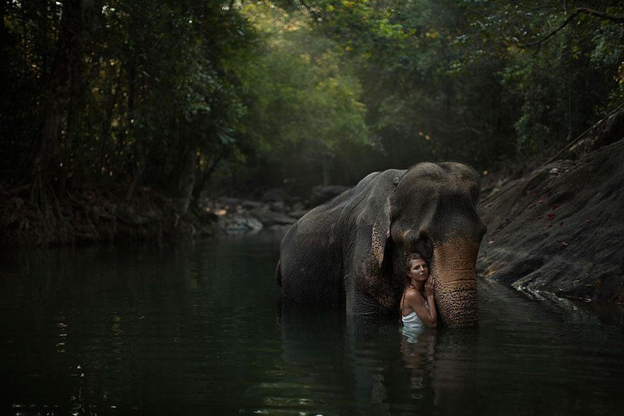
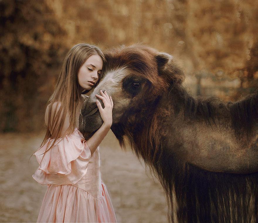
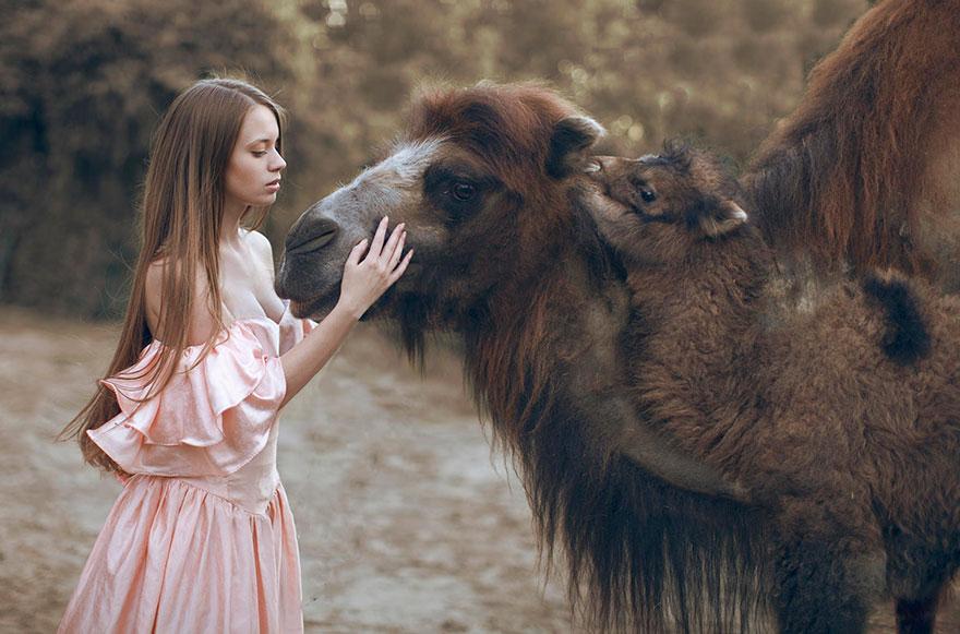
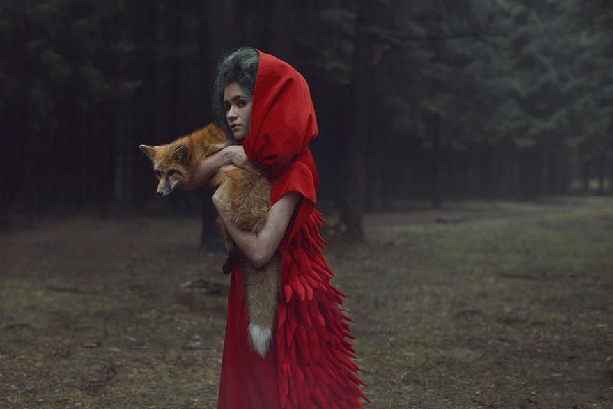
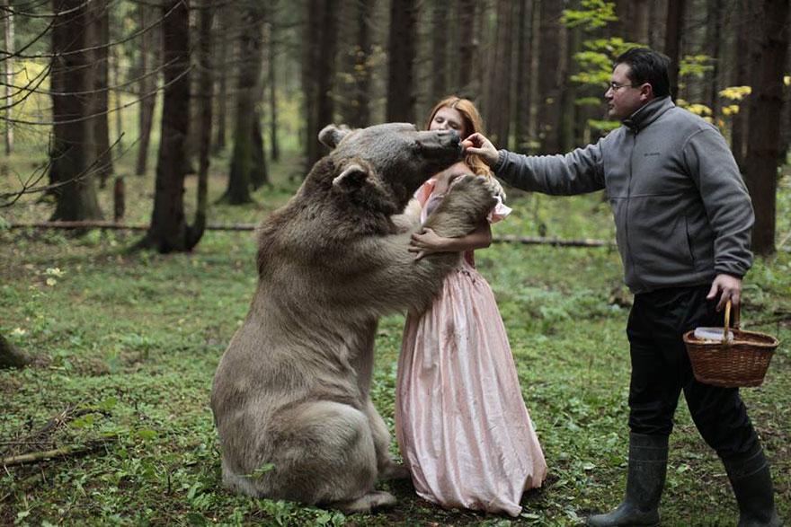
What you’re about to see is not Photoshop – Moscow-based Russian photographer Katerina Plotnikova created these stunning images with the help of real live animals! She is only the latest in a line of excellent surreal photographers , but her unique choice of models brings her amazing compositions to the next level.
While seemingly dangerous, these shots were made possible with the help of professional animal trainers. The bear, held by many as a symbol of primal strength and instinct, contrasts especially well with the elegant princess it has embraced. Fortunately, she has provided us with a few adorable behind-the-scenes photos showing how the animals are posed by their trainers, including a shot where the bear sneaks a snack from its trainer over the model’s shoulder.
Even without the well-trained animals, her photos possess a rich mysticism and dream-like quality that makes them absolutely enchanting. Plotnikova’s human models exude a quiet regal air that is only made all the more arresting by their animal companions.
Source: Facebook | Vkontakte | 500px
You might think you’ve heard all there is to know about the Eiffel Tower, which turns 125 today. But you might be surprised at some of the quirky things we’ve unearthed in its history:
1. The Eiffel Tower was built in two years, two months, and five days—a record back in the late 1880s. It was officially completed on March 31, 1889.
2. It was only supposed to last for 20 years. Gustave Eiffel had it built specifically to celebrate the 100th anniversary of the French Revolution.
3. It hasn’t always been brown. It was briefly painted yellow in 1889, and from 1954 to 1961, it was painted a brownish-red color.
4. In the late 1920s and early 1930s, the Eiffel Tower acted as a billboard—three of its sides held advertisements for Citroën automobiles. No other brand has ever used the monument as an advertising medium.
5.The French originally hated it. A number of high-profile creatives and architects signed a petition to protest the tower during its construction. They called the tower “useless” and “monstrous.”
6.It played a crucial role in the First World War, during the Battle of the Marne in 1914. Signals would actually be sent out from the top of the tower, directing the French troops to the front line.
7. In 1889, the French newspaper Le Figaro actually set up a printing press on the second floor of the Eiffel Tower.
8.The Eiffel Tower shrinks. Seriously, it’s been measured. In the winter it is approximately four to eight inches shorter.
9.Welcoming around seven million visitors each year, it’s the most visited monument in the world that you have to pay for. (The Empire State Building only draws around 3.5 million visitors each year).
10. Every night, every hour on the hour the tower is covered in golden lights and will sparkles for five whole minutes while the Eiffel Tower’s beam lights up the city. The best place to see the light show is from is Place du Trocadéro.
When you think about the Incas, does come to mind? While that might be where your destination starts or ends in Peru, there is so much more to see in the Sacred Valley of the Incas, or El Valle Sagrado de los Incas. Look up along the Urubamba River and Valley to see Andes Mountain peaks stretching to a height of 20,000 feet. It is over these steep hillsides that the Incas managed to move massive stones without the help of the wheel. They had no iron tools to cut the stones, but still the pieces fit together so tightly that not even a knife blade can slide between them. The “how’s” are part of the secrets to which we might never know the answers. Huge circular terraces at Moray were thought to be where Incas conducted experimental agriculture. Carved into the mountains are also thousands of small salt ponds, Salineras de Maras, or Inca salt pans. All of this is located in the Peruvian Andes, with Cusco on one end and Machu Picchu on the other; this is the heartland of the Inca Empire. This is the Sacred Valley of the Incas.
Inca salt ponds, Sacred Valley in Peru. The photographer wrote, “Indians mined salt slopes of the valley from pre-Inca times. Today, 700 to 800 families owning some 3600 basins are organized as a cooperative. The total annual production varies between 160 and 200 tons.” Photo #1 by David (Wanaku)
If you zoom out, this is Sacred Valley of the Incas in the Peruvian Andes. The photographer noted that Sacred Valley has “numerous archaeological monuments and indigenous peoples. This valley was appreciated by the Incas due to its special geographical and climatic qualities.” Photo #2 by Alfredo Miguel Romero
Inca terraces of Moray. According to En Peru, “Some say Moray was an Inca laboratory used to test how different crops would perform at different temperatures. Others say it was a more of a nursery where crops were bred and cross-bred, varieties created and new foreign crops tested. A third group says it was just an ingenious means to grow warmer climate maíz or corn in the local cold climate. Whoever is right, this archaeological site of concentric circles of terraced farms, forming craters in the landscape, are a fascinating sight to behold.” Photo #4 by Boris G
Imagine coming through the mountainside to see the shocking patch of white and thousands of salt ponds. Salinas de Maras is clearly visible on an aerial map view. Photo #5 by dachalan
Salt pans at Maras during wet season. “We visited during the wet season when yield is not optimal; the ponds are also more colorful during dryer times.” The photographer added that families working the ponds make less than $3 per 50 kg bag of top quality salt. Photo #6 by Pierre Pouliquin
Inca Salt Ponds, “Salineras.” Salt has been harvested from the briny waters of the Salineras spring for thousands of years. There are thousands of salt pans nestled in a canyon, which are used to evaporate water to extract the salt. The salty water is directed to the ponds by an intricate network of channels. Once the pond is filled, the flow of water is cut and it is allowed to dry. Salt precipitates in crystals, and when dry it can be harvested. The salt pan is run on a cooperative system.” Photo #7 by Pierre Pouliquin
Salt Pans during August. En Peru explains, “A saline stream once flowed through here before, in ancient times; it was captured and used for salt production. The stream was redirected to flow along channels higher up the walls of the gully and at each stage some water is let out to flow into man-made ponds that fill the rest of the gully. Once full, the water in the pond (or pan) is allowed to naturally evaporate leaving salt crystals that can be collected. The process is then repeated.” Photo #8 by dachalan
Salt pans, Salineras de Maras, are owned by locals. It’s back-breaking work, but some of the salt ponds “have been in the same family, passed down from generation to generation for as long as anyone can remember. They are formed into a cooperative and sell the salt together.” In fact, local residents and pond workers agree “that the cooperative system was established during the time of the Incas, if not earlier.” Photo #9 by dachalan
An ancient civilization thrived in this part of Peru. “It was called the Sacred Valley because it contains some of the best land in the region and was not a part of the Empire but the property of the Emperor or Inca himself.” Photo #10 by dachalan
Salt Mines are near Maras, which “was occupied when Cusco citizens left the Inca palaces in Cusco and had to migrate to other small towns as Maras and San Sebastian. This populated area was a necessary step for carriers and their mule trains that carried tropical products, specially coca leaves from thejungle to satisfy the needs of Cusco and the country.” Photo #11 by McKay Savage
Many people believe the salt pans were being used by pre-Inca natives, before Incas set up house in Sacred Valley, between 200 AD and 900 AD during the Chanapata culture. Photo #12 by McKay Savage
“Square-shaped salt ponds cascading like a chessboard down this part of the salt flats.” The photographer added, “The Salineras salt pans are among the most amazing sights in the Cusco area. Thousands of tiny terraces of white, pink and coffee brown evaporate salty mineral water to produce fine salt.”Photo #13 by McKay Savage
The photographer wrote, “It all starts with a hot spring highly loaded in salt; the water is directed to ponds downhill where salt is harvested after evaporation.” Wikipedia added, “As water evaporates from the sun-warmed ponds, the water becomes supersaturated and salt precipitates as various size crystals onto the inner surfaces of a pond’s earthen walls and on the pond’s earthen floor.” Photo #14 by Pierre Pouliquin
Salt ponds in Dec. Other people believe these salt ponds have been panned for centuries, but the water-flow system was developed by the Incas. Photo #15 by Emmanuel Dyan
It’s not like this is a major tourist attraction, but it is a strangely unique site to behold. Wikitravel said, “On the main route to Incan sites of Salineras and Moray, Maras is an otherwise unremarkable dusty town.” Photo #16 by Kenneth Moore
Some people make the trek through the Sacred Valley and to Machu Picchu via the Inca Trail along which these Pisac ruins can be found. The photographer wrote, “The terraces, called andenes, surrounding the Pisac ruins sits high over the Sacred Valley.” The residential zone of the Incan ruins at Pisaq is on top, but the ruins are also spread out on the mountains into a large agricultural section with terraces. Photo #17 by McKay Savage
Gorgeous Sacred Valley of the Incas patchwork fields and mountain landscape next to Moray. Photo #18 by Boris G
Moray is an archaeological site next to Cusco, Peru. It consists of several circular terraces created by the Incas as you can see in an aerial map view.Photo #19 by Boris G
Urubamba Valley. BBC said, “Peru’s Sacred Valley of the Incas stretches between Cusco, once the capital of the Inca Empire, and the legendary 15th-century city of Machu Picchu. Encompassing what was the fertile homeland of the Inca Empire (1438 to 1533), today the transcendent region – also known as the Urubamba Valley – is a quiet expanse of country that is steeped in Andean history and culture.” Photo #20 by Charles Gadbois
Sacred Valley, Ollantaytambo, mountain Inca archaeological site. You can view the Inca site on the mountainside in an aerial map. Ollantaytambo “is where the Incas retreated after the Spanish took Cuzco. Much of the town is laid out in the same way as it was in Inca times. The ruins of Ollantaytambo are largely of religious significance; they doubled as the the last and largest defensive structures near the plains below where the Incas defeated the Spaniards in battle.” Photo #21 by Emmanuel Dyan
“Ruins of granaries on the hillside over Ollantaytambo, an Inca archaeological site in the Sacred Valley.” The photographer wrote, “Reportedly grain was tipped in the uphill window, then removed from the downhill side.” Ollantaytambo “was once a country retreat for Inca royalty and nobility.” It was also where the Incas fought some of their last battles, resisting Spanish conquest from the still-intact fortress and staggered terraces rising up around the town. Climbing to the top of the village’s ceremonial center where Incas would worship, yields panoramic views of the Sacred Valley and across the Patakancha and Urubamba Rivers.” Photo #22 by Stevage
Regarding Pisac, the BBC said, “Trails lead over and through the terraces, tunnels, temples, tombs and ceremonial centre – all engineered by the Incas for farming, worshipping and bathing. The Sun Gate, included in many of the Inca’s lofted towns, perfectly frames the setting sun during biannual solstices, as it has and will continue to do for centuries. The splendid views down and across the Urubamba Valley rival those of Machu Picchu, and unlike the iconic site, visitors often have hushed Pisac almost entirely to themselves.” Photo #23 by Unukorno
Saksaywaman (Saqsaywaman) was an Inca military fortress above Cusco. The precision of the stone work shows us that the Incas were masters who supposedly had no “math” and no tools but rocks to chisel the boulders into fitting tightly together. It’s also said they didn’t write things down yet managed to keep excellent records. Saksaywaman is still used during Inti Raymi, a solstice festival that was a religious “Festival of the Sun” for the Incans.Inti Raymi “really was the celebration of the Winter Solstice – the shortest day of the year in terms of the time between sunrise and sunset. In Peru, which falls below the equator, the months of June and July are Winter months.” Photo #24 by McKay Savage from London, UK
Sacred Valley of the Incas has numerous ancient villages, temples and ruins besides the famous rediscovered “lost” city of Machu Picchu located farther north and higher up into the mountains. Photo #25 by Daniel Antunes
Tipón water channeling. The photographer noted, “What makes Tipón an interesting Incan site is the sophisticated water distribution through the agriculture terraces, water running through stone-lined channels and out spouts to different levels and parts.” Photo #26 by McKay Savage
Varied color and texture of stone mastery without motor, Incan walls at Pisac, Peru. Photo #27 by McKay Savage
Huchuy Qusqu, or “Little Cuzco” lies at an elevation of 11,800 feet (3,600 m) above the 3000-meter high town of Lamay and the Sacred Valley. It is not accessible by road. Photo #28 by Stevage
The mystery at Moray, Inca agricultural experiment station. The photographer points out, “Surprisingly, for wiki in GB, the function of this site is only hypothetical; it is not for wiki in other languages, nor for the locals who keep Quechua tradition (Quecha, language of the people ‘administered’ by the Inca).” Indeed when looking up Moray in languages other than English, its purpose for experimentation is stated as a fact. “At first glance, the site looks like a main auditorium and two secondary, smaller nearby. They consist of several terraces arranged in concentric circles. In fact, it was a center of Inca agricultural research where experiments were performed.” Photo #29 by Pierre Pouliquin
Inca terraces of Moray: The site contains unusual Inca ruins, mostly consisting of several enormous terraced circular depressions, the largest of which is about 30 m (98 ft) deep. The purpose of these depressions is uncertain, but their depth and orientation with respect to wind and sun creates a temperature difference of as much as 15 °C (27 °F) between the top and bottom. This large temperature difference was possibly used by the Inca to study the effects of different climatic conditions on crops. In other words, Moray was perhaps an Inca agricultural experiment station. As with many other Inca sites, it also has a sophisticated irrigation system.” Photo #30 by Os Putos
If Inca stonework is what you want to see, many photographers suggested Pisac where viewing the ruins is not as crowded as other ruins. En Peruwrote, “They might not be in a location quite as beautiful as Machu Picchu, or on a scale quite as monumental as Sacsayhuamán, but the stonework here is some of the best you will ever see in Peru or elsewhere.” Photo #31 by Vautrin_Baires
View of Machu Picchu from Wayna Picchu (the high hill that rises behind machu in all photos). Photo #32 by Rodrigo Alvarez
Machu Picchu may be your “main” destination, but there are plenty of mysterious ruins and secrets in the Sacred Valley of the Incas. Photo #33 by Pedro Szekely
Moray Terraces: “There are three separate ‘bowl’ shaped groups of concentric terraces. One has been restored and is being used by local farmers. Each has stone retaining walls with carved channels for carrying water and steps for climbing into and out of the structure. There was possibly a ceremonial use for the site as well. But none is recorded by the Spanish writers of the conquest and there is no ceremonial folk tradition associated with the Terraces.”Photo #34 by McKay Savage
Urubamba River, natural beauty in the Sacred Valley. There are some massive pieces of rock left abandoned by the Incas along the Inca trail; they are much more massive than these and were pulled by humans and not oxen. The huge abandoned rocks are called “weary stones.” Photo #35 by Rod Waddington from Kergunyah, Australia
Amazing giant rocks, architecture so precise a knife can’t be wedged between the massive stones. Can you imagine the Incas moving those without the benefit of wheels? Photo #38 by Martin St-Amant
It might seem a bit odd, but today in the Sacred Valley of the Incas, visitors can go bungee jumping, horseback riding, hot-air ballooning, paragliding, mountain biking, trekking, white-water rafting and ziplining. Photo #39 by
McKay Savage
Meanwhile, as a polar opposite of tourists trying out extreme sports in the Urubamba Valley, locals try to etch out a back-breaking living by mining salt at Maras. Photo #40 by Emmanuel Dyan
October afternoon at the salt pond of Maras. Machu Picchu is less than a two hour drive north from here. As you have seen, the Sacred Valley in Cusco is full of salt, stones and secrets that leave questions to which we may never know the answers. Photo #41 by McKay Savage
Viva El Peru, Inti Raymi solstice festival, Sacred Valley of the Incas. Frommers stated, “The Incas built several of the empire’s greatest estates, temples, and royal palaces between the sacred centers of Cusco and Machu Picchu, positioned like great bookends at the south and north ends of the valley.”Photo #42 by McKay Savages
At the heart of Picos de Europa National Park in northern Spain, an adventure awaits hikers. The trail consists of 9 miles along the Cares River and the Cares Gorge, aka “divine gorge.” Steep cliffs stretch up over 6,500 ft (2,000 m) on one side and the Cares River is as far as 650 feet (200 m) below in the deep gorge. The Cares Gorge trail is extremely popular because it is considered one of the most beautiful walks in all of Spain. The footpath was improved about 60 years ago when tunnels were carved into the mountain to serve as a maintenance trail to a hydroelectric power station. Long ago, some sections of the path were used by shepherds, sheep and even goats; the route provided the only communication between 2 villages when it was snowy. The national park was also named a biosphere reserve by UNESCO. If you visit Spain, you might want to reserve a day to trek this beautiful trail.
Look beyond the water, Cares Chanel or Canal del Cares, and then up at the narrow pathways carved into stone to see one of the most beautiful hiking adventures in Spain. This trek is along the Cares River and through the Cares Gorge in Picos de Europa National Park. The Cares Gorge has many names like “Divine Gorge” or Garganta del Cares, but everyone agrees on its rugged beauty. Photo #1 by David Valije
Care Gorge Route: Narrow paths with steep cliffs stretching up over 6,500 ft (2,000 m) on one side and the Cares River far below on the other side. Photo #2 by Raúl González
Walk on the wild side, Cares Gorge in Spain. Part of the footpath was once nothing more than a goat trail, traveled by animals and shepherds long ago. This ancient route provided the only communication between the villages of Caín (León) and Poncebos (Asturias) during snowy winters. In the 1940s, the electricity company Viesgo carved a trail high up into the craggy gorge walls; it was a maintenance path to service the Poncebos hydroelectric canal that runs between Cain and Camarmena along the Cares River. Photo #3 by Jose Luis Canales
Cares River Route in the heart of Picos de Europa National Park is 9.321 miles (15 km) long one way. The walk takes an estimated 3 to 4 hours one way, or 6 to 8 round trip. Photo #4 by Max Westby
Today people can appreciate the trek with gorgeous landscapes, but many men lost their lives while digging into limestone rocks to create the Cares Route, or Ruta del Cares. Photo #5 by Jose Luis Canale
Crowds walk the path through Cares Gorge. It is advised not to take the route “during the month of August or summer during the weekend due to the large crowds that occur.” Photo #6 by _Lares
People with vertigo may not want to take the “La garganta divina (Asturias – León)” hike, but everyone should bring plenty of water to stay hydrated as there is not much shade. The footpath is about 8 feet wide in places, but all adventurers should keep an eye out as rock-slides are always possible. Photo #7 by Raúl González
If you go early and avoid weekends, holidays and summer, you might be like this lone hiker on the route? Yet spring and autumn are noted to be the most beautiful times of the year to make the trek. Photo #9 by Ramón Pérez Niz
A rainbow over the Cares Gorge. The route is free of charge and open all year round, but can be tricky if there is snow near the village of Cain. Walkers should be alert for possible falling rocks when it snows, rains heavily, or during the “thaw.” Photo #10 by Asociación Anciles
Adventure at Garganta del Cares. Paraphrasing this Hiking in Spain book: Despite this classic Picos walk being almost too popular, it’s earned this popularity for a very good reason. It’s well worth braving the maddening crowds to get a piece of the action. The walk, though long, is easy and is undertaken by all ages and walking abilities. Photo #11 by Senderismo Sermar
The photographer noted, “In the Asturian part of the Ruta del Cares, a few meters from the border with León, I found this natural setting :-)” Photo #12 by Jorge Cabrera
Picos de Europa National Park in northern Spain was created in 1918. In 2003, UNESCO approved Biosphere Reserve status for the National Park. Photo #13 by ccdoh1
Looking treacherous at this point of the 9 miles of natural beauty between the towns of Leon and Poncebos Cain in Asturias, Spain. Photo #14 by Erik Daugaard
“Somewhat complicated,” wrote the photographer. There are some places along the gorge route where the river is 650 feet (200 meters) below. Photo #15 by Ramón Pérez Niz
Trickling water at Garganta del Cares. Although many people choose to start the trail in Caín and end in Poncebos, adventurers can start the walk from either town or hike to one and round trip back again. Photo #16 by Ramón Pérez Niz
Hikers on “The Divine Gorge” route. The Cares canal was built between 1916 and 1921, but it took another couple decades before a footpath was carved through the limestone as a maintenance path for a hydroelectric dam. Photo #17 by Erik Daugaard
Walkopedia scores Cares Gorge (Garganta del Cares) as an 87 mostly for its beauty, but “crowded at high season and at weekends” was a noted negative. Photo #18 by Senderismo Sermar
Sheep seen while hiking along the divine gorge, Ruta Del Cares. About 1,300 people live in Picos de Europa National Park. Photo #26 by Senderismo Sermar
Rushing rapids at Cares Gorge. As a biosphere reserve, the national park and Cares Gorge will remain mostly untouched by modernization. A hiking magazine suggested bringing along your cell phone even though you won’t have a signal for the entire hike. Photo #27 by Ronnie Macdonald
During the holidays and summer, the trail is traversed by thousands of people as if it were part of a main street in a big city instead of miles of trail out in nature. Photo #30 by ccdoh1
Cares Gorge Fauna, Picos de Europa. The photographer added, “Don’t annoy the natives!” There were quite a lot of goat photos along the route, some noted to take care if goats above you on the rocky mountains are descending as this too could potentially cause falling rocks. Photo #31 by NicolaJH
This beautiful route in the national park has hanging bridges, waterfalls, tunnels and caves. Photo #32 by Jorge Cabrera
According to Wikipedia, “The Cares is known because of the narrow and spectacular canyon it forms when passing the Asturian Massif, there is a famous trekking path known as ‘Ruta del Cares’ that runs along the river, being one of the most remarkable Asturian geographical attractions. The Cares river is also known because of the quality of its salmon.” Photo #34 by Ramón Pérez Niz
Cares Gorge (Garganta del Cares) footpath, Picos de Europa National Park, Castilla y Leon, Spain. Photo #35 by rolando000 / Bing
These 24 thought provoking questions I am sharing with you today have no right or wrong answers. Asking them is the answer. Voltaire, the writer, historian, and philosopher of the French Enlightenment era, admonishes us to judge a man by his questions rather than his answers: you’ll get to know someone better by asking them the right questions. In the same way, you know yourself better by asking yourself the right questions.
What would people say about you at your funeral?
What do you believe stands between you and complete happiness?
When will you be good enough for you? Is there some breaking point where you will accept everything about yourself?
If you were at heaven’s gates, and God asked “you why should I let you in?”, what would you say?
Do you fear death? If so, do you have a good reason?
If you lost everything tomorrow, whose arms would you want to run into? Does that person know how much they mean to you?
If you had the chance to go back in time and change one thing, what would you change?
If you could make a 30 second speech to the entire world, what would you say?
If you had all the money in the world but still had to have some kind of job, what would you choose to do?
What would you change if you were told with 100% certainty that God does not exist? Or if you don’t believe in God, that he does exist?
What would you change if you knew you were NEVER going to die?
If this were the last day of your life, would you want to do what you were about to do today?
If your life was a movie, what would be the title?
If you could ask for one wish, what would it be?
How could you describe yourself in 5 words?
Are there chances you’ve passed up that you wish you’d have taken?
How old would you be if you didn’t know how old are you?
If not now, then when?
What would you do differently if you knew nobody would judge you?
Are you aware that someone has it worse than you?
If you had to choose between a book or a movie what would you choose?
If you could see your whole life till now on a movie would you enjoy it?
If you could ask 1 person just one question, and he would answer honestly, what would you ask him and who would you ask?
What would you do different if you were reborn?
I know some of these thought provoking questions might seem uncomfortable, but it’s important to remember they give us valuable insight on ourselves and guide us to live in ways that bring the most fulfillment and joy.


 Cusco, Peru")


 in Maras Peru in March")


.jpg)


")


